So I thought it might be fun to hike the Hardergrat in the Bernese Alps by myself. Turns out it was mostly type two fun: It was the most terrifying, exposed and strenuous hike I ever did. It was however also one of the most beautiful ones. Here’s to 10 hours of testing my limits and getting some amazing views in return.
It took me a while to figure out in which direction I wanted to do the hike. There is the option to start in Interlaken and end at the Brienzer Rothorn, gaining more altitude than you are descending. Or there was the option of starting on the top at the Brienzer Rothorn and descending until Harder Kulm, where you can take a cableway down. Since I knew the hike was going to be strenous enough as it is, I decided to spend the night at the guesthous up Brienzer Rothorn and start my hike the next morning well fed and well rested.

I got up at 4:30am, ate a little breakfast and left the hotel by 5am to start the long trail along the ridge. It was still a little cold, I was happy i wore my down jacket and made good progress. I wasn’t sure whether there would be any snow still left on the trail (that was in early June), but I hoped that the warm weather of the past few weeks had cleared the path. Turns out that was correct for the most part, but not quite all of it. About an hour into the hike i had to descend a gnarly gully still filled with snow, the steps all but gone and the cables not really up yet. I carefully lowered myself down that steep and muddy slope, which worked out incident-free, but left me covered in mud and sweat only an hour into the hike. Good thing I was quite on my own on the trail.

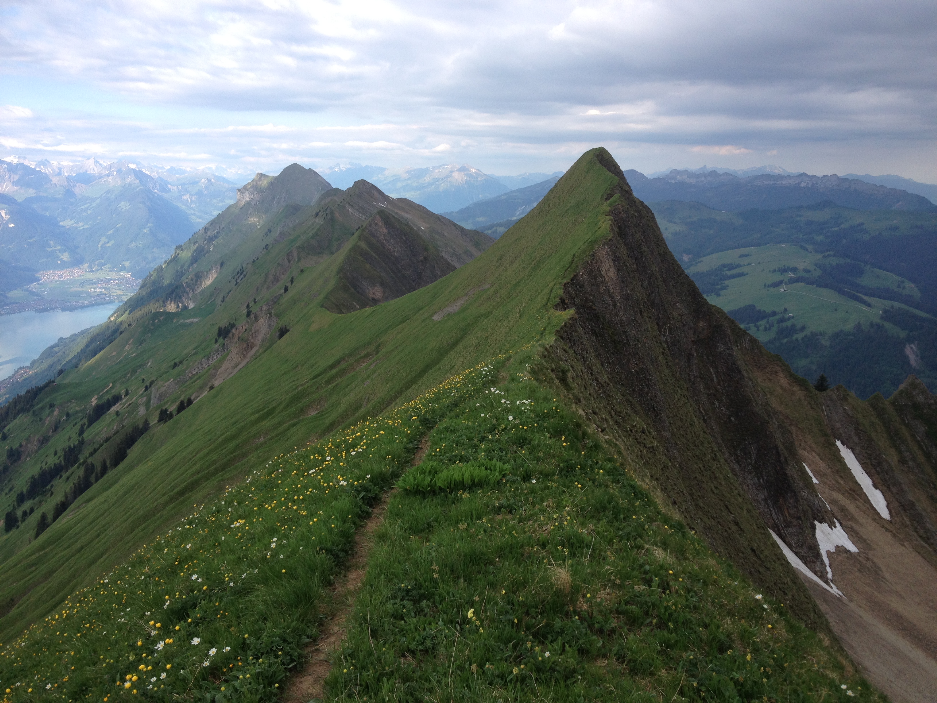
The following kilometers on the trail were much easier, yet still strenuous. The trail winds its way along the ridge, going up and down, with steep descends on both sides and sections of the trail so steep and rocky that you need to use your hands to get safely up and down. It was an at the same time terrifying and exhilarating adventure I set myself up for.

But there were also the rewards to the hardship: I came across a herd of ibexes just casually grazing next and on the trail, not in the least afraid of me and letting me take pictures from up really close.

I got to see a sun rise over the Brienzer Rothorn illuminating the whole ridge in a soft, beautiful light.

I summited the Tannhorn and got to make an entry in the registry, the first on this day.
I got some amazing views of the Swiss alps and after the clouds lifted a little a glimpse of the famous mountain trio Eiger, Mönch and Jungfrau.


I met the first fellow hikers after a few hours on the Augstmatthorn, which is part of the official hiking trail network again. By that time I was pretty exhausted (“Well this is much longer than I thought” and “It can’t possibly be this far still”) and my knees were sort of done with going downhill. I did have quite some kilometers left that were not difficult anymore, but that felt really, really, really long. On and on the trail went through the forest until finally the viewing platform of Harder Kulm came into view and with it the day tourists, the sounds of laughter and holidays and excitement and, once I made my way to the cable car, the bliss of being able to splash some cold water onto my face and to finally sit down and take a rest.


Information:
Route: Brienzer Rothorn – Tannhorn – Augstmatthorn – Suggiture – Harder Kulm
Distance: 27 km
Total Altitude gain: 2500 m
Total Altitude loss: 3000m
One-Time-Donation
I love writing about the places I discover, and want to keep this website free. However, if you find something of use and inspiration to you on my blog, please consider a donation. It will keep me in coffee and thus the blog content coming. Your support matters greatly and I appreciate it!
2.50 CHF
